
Dymaxion map


The Dymaxion map projection, also called the Fuller projection, is a kind of polyhedral map projection of the Earth's surface onto the unfolded net of an icosahedron. The resulting map is heavily interrupted in order to reduce shape and size distortion compared to other world maps, but the interruptions are chosen to lie in the ocean.
The projection was invented by Buckminster Fuller. In 1943, Fuller proposed a projection onto a cuboctahedron, which he called the Dymaxion World, using the name Dymaxion which he also applied to several of his other inventions. In 1954, Fuller and cartographer Shoji Sadao produced an updated Dymaxion map, the Airocean World Map, based on an icosahedron with a few of the triangular faces cut to avoid breaks in landmasses.
The Dymaxion projection is intended for representations of the entire Earth.
History
[edit]The March 1, 1943, edition of Life magazine included a photographic essay titled "Life Presents R. Buckminster Fuller's Dymaxion World". The article included several examples of its use together with a pull-out section that could be assembled as a "three-dimensional approximation of a globe or laid out as a flat map, with which the world may be fitted together and rearranged to illuminate special aspects of its geography".[1] Fuller applied for a patent in the United States in February 1944, showing a projection onto a cuboctahedron, which he called "dymaxion". The patent was issued in January 1946.[2]
In 1954, Fuller and cartographer Shoji Sadao produced a new map onto an icosahedron instead of the cuboctahedron. It depicts Earth's continents as "one island", or nearly contiguous land masses. References today to the Fuller projection or Dymaxion usually indicate this version.
Projection of each triangle
[edit]Unlike other polyhedral map projections, the Dymaxion map does not use a gnomonic projection (perspective projection through the Earth's center onto the polyhedral surface), which causes length distortion away from the center of each face. Instead each triangle edge of the Dymaxion map matches the scale of a partial great circle on a corresponding globe, and other points within each facet shrink toward its middle.[3] Fuller's 1980 version of the Dymaxion map was the first definition and use of a mathematical transformation process to make the map.[4][5][6][7]
Properties
[edit]
Though neither conformal nor equal-area,[8] Fuller claimed that his map had several advantages over other projections for world maps.
It has less distortion of relative size of areas, most notably when compared to the Mercator projection; and less distortion of shapes of areas, notably when compared to the Gall–Peters projection. Other compromise projections attempt a similar trade-off.
More unusually, the Dymaxion map does not have any "right way up". Fuller argued that in the universe there is no "up" and "down", or "north" and "south": only "in" and "out".[9] Gravitational forces of the stars and planets created "in", meaning "towards the gravitational center", and "out", meaning "away from the gravitational center". He attributed the north-up-superior/south-down-inferior presentation of most other world maps to cultural bias.
Fuller intended the map to be unfolded in different ways to emphasize different aspects of the world.[10] Peeling the triangular faces of the icosahedron apart in one way results in an icosahedral net that shows an almost contiguous land mass comprising all of Earth's continents – not groups of continents divided by oceans. Peeling the solid apart in a different way presents a view of the world dominated by connected oceans surrounded by land.
Showing the continents as "one island earth" also helped Fuller explain, in his book Critical Path, the journeys of early seafaring people, who were in effect using prevailing winds to circumnavigate this world island.
However, the Dymaxion map can also prove difficult to use. It is, for example, confusing to describe the four cardinal directions and locate geographic coordinates. The awkward shape of the map may be counterintuitive to most people trying to use it. For example, the shortest route from Africa to South America is not obvious. Depending on how the map is projected, land masses and oceans are often divided into several pieces.
Conformal variant
[edit]In 2019, Daniel "daan" Strebe developed a conformal icosahedral projection, similar to the conformal projections to an octahedron by Oscar S. Adams (1928) and to a tetrahedron by Laurence P. Lee (1965), all three using Dixon elliptic functions. A conformal map preserves angles and local shapes from the sphere at the expense of increasing the scale distortion near the vertices of the icosahedron.[11]


Comparison of the Fuller projection and Strebe's Dymaxion-like
conformal projection with Tissot's indicatrices at 30° intervals
Influence
[edit]A 1967 Jasper Johns painting, Map (Based on Buckminster Fuller's Dymaxion Airocean World), depicting a Dymaxion map, hangs in the permanent collection of the Museum Ludwig in Cologne.[12][13]
The World Game, a collaborative simulation game in which players attempt to solve world problems,[14][15] is played on a 70-by-35-foot Dymaxion map.[16]
In 2013, to commemorate the 70th anniversary of the publication of the Dymaxion map in Life magazine, the Buckminster Fuller Institute announced the "Dymax Redux", a competition for graphic designers and visual artists to re-imagine the Dymaxion map.[17][18] The competition received over 300 entries from 42 countries.[17]
The H3 hierarchical global grid implemented by Uber uses an icosahedron oriented in Dymaxion orientation, then further subdivided into hexagons.[19]
In 2020, a collaborative effort by thousands of Minecraft players, the Build the Earth project, used Strebe's conformal variant as a projection for building a 1:1 scale representation of the Earth inside the game.[20]
Gallery
[edit]-
 This icosahedral net shows connected oceans surrounding Antarctica.
 -
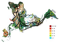 Example of use illustrating early human migrations according to mitochondrial population genetics (numbers are millennia before present)
 -
 Dymaxion map of the world with the 30 largest countries and territories by total area, roughly to scale


See also
[edit]- List of map projections
- Authagraph projection, inspired by Fuller, 1999
- Peirce quincuncial projection, 1879
- Polyhedral map projection, earliest known is by Leonardo da Vinci, 1514
References
[edit]- ^ "Life Presents R. Buckminster Fuller's Dymaxion World". LIFE. 1 March 1943. pp. 41–55.
- ^ U.S. patent 2,393,676
- ^ Fuller, Ideas and Integrities (1969 ed., p. 139).
- ^ Gray, Robert W. (1994-01-01). "Fuller's Dymaxion Map". Cartography and Geographic Information Systems. 21 (4): 243–246. doi:10.1559/152304094782540628 (inactive 31 January 2024). ISSN 1050-9844.
{{cite journal}}: CS1 maint: DOI inactive as of January 2024 (link) - ^ Gray, Robert W. (1995-10-01). "Exact Transformation Equations for Fuller's World Map". Cartographica: The International Journal for Geographic Information and Geovisualization. 32 (3): 17–25. doi:10.3138/1677-3273-Q862-1885. ISSN 0317-7173.
- ^ Crider, John E. (2008-03-01). "Exact Equations for Fuller's Map Projection and Inverse". Cartographica: The International Journal for Geographic Information and Geovisualization. 43 (1): 67–72. doi:10.3138/carto.43.1.67. ISSN 0317-7173.
- ^ "Dymaxion Map Transformations - Technical White Paper", Kitrick, Christopher, 2018
- ^ "Fuller—ArcGIS Pro | Documentation".
- ^ Fuller, Intuition (1972).
- ^ "Frequently Asked Questions About The Fuller Projection", Buckminster Fuller Institute, 1992, accessed 2010-07-28
- ^ Strebe, Daniel. "Directory of Map Projections: dymaxion-like conformal". Mapthematics. Mapthematics LLC. Retrieved 2022-06-19.
- ^ "Kulturelles Erbe Köln: Johns, Jasper, Map (Weltkarte)". www.kulturelles-erbe-koeln.de. Retrieved 2017-01-18.
- ^ "Ausstellung "Ludwig goes Pop"".
- ^ Richards, Allen (May–June 1971). "R. Buckminster Fuller: Designer of the Geodesic Dome and the World Game". Mother Earth News. Retrieved 19 January 2014.
- ^ Aigner, Hal (November–December 1970). "Sustaining Planet Earth: Researching World Resources". Mother Earth News. Retrieved 19 January 2014.
- ^ Perry, Tony (October 2, 1995). "This Game Anything but Child's Play : Buckminster Fuller's creation aims to fight the real enemies of mankind: starvation, disease and illiteracy". The Los Angeles Times. Retrieved 19 January 2014.
- ^ a b "DYMAX REDUX Winner". The Buckminster Fuller Institute. Archived from the original on 2 February 2014. Retrieved 21 January 2014.
- ^ Campbell-Dollaghan, Kelsey (July 22, 2013). "7 Brilliant Reinventions of Buckminster Fuller's Dymaxion Map". Gizmodo. Retrieved 21 January 2014.
- ^ Brodsky, Isaac (June 27, 2018). "H3: Uber's Hexagonal Hierarchical Spatial Index". Uber Blog. "Overview of the H3 Geospatial Indexing System". H3 documentation. Uber.
- ^ Karel, Daniel (March 10, 2022). "The 2,731-Person Project to Build New York City in Minecraft". Curbed. Retrieved 2024-09-03.
External links
[edit]- Fuller Map homepage
- Dymaxion Project Animation
- Icosahedron and Fuller maps
- Dynamically generated maps based on the Dymaxion projection
| International | |
|---|---|
| National | |